


1. Introduction
With the continuous advancement of satellite remote sensing technology, satellite imagery has become a crucial means of acquiring surface information. However, satellite images often contain significant amounts of interference, such as buildings, trees, and more, which complicates the extraction of target information like roads. The primary focus of this study is to effectively extract road information from satellite images. This involves accurately distinguishing roads from other interferences and appropriately processing the images to achieve optimal road extraction results. To address the aforementioned issues, we employed morphological techniques. Specifically, we first enhanced image contrast to improve the computer's ability to recognize objects within the images. Then, we utilized convolution erosion and dilation techniques to selectively remove non-road interferences like buildings and trees. Through these morphological operations, we were able to better emphasize road features, thereby achieving effective road information extraction.
The significance of this study lies in providing an effective method for accurately extracting road information from complex satellite images. This is important in fields such as urban planning and traffic management. Additionally, by employing morphological approaches, we offer a novel perspective and methodology to the field of image processing. We were able to extract road information from satellite images and validated the effectiveness and outcomes of our method by comparing images before and after processing. This contributes to enhancing the computer's recognition capabilities concerning satellite images and provides more accurate surface information for various practical applications.
2. Design methodology
This project primarily employs convolution dilation and erosion techniques, as well as gradient computation methods, which fall under the domain of morphology [1]. The primary objective of these tools is to enhance image quality through the process of resizing, both enlarging and reducing the dimensions. The desired matrix, referred to as the kernel, is specified within a 3x3 range. Following the convolution operation, the pixel value is determined as the maximum value within the 3x3 neighborhood centered on the pixel [2]. By employing this method, the objective of increasing the pixel count can be accomplished (see Figure 1B). Next, the distractor term is expanded and inverted in order to obtain the erosion term (Figure 1C). Ultimately, the gradient calculation is employed to obtain the contour, as depicted in Figure 1D.
A | B |
|
|
C | D |
|
|


Figure 1. The image obtained after various technical operations.
1A: Original image of example., 1B: Image after Dilation, 1C: Image after Erosion. 1D: Image after Gradient Computation.
The flowchart for the specific operation is shown in the following diagram (Figure 2):
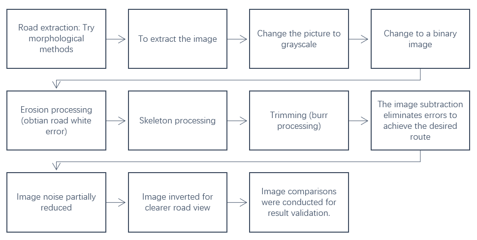
Figure 2. Road extraction process using principles of image analysis.
In the subsequent section, we shall elucidate the distinct process of our project from multiple perspectives.
2.1. Extraction of Roads
In order to obtain the satellite imagery of the road, it is necessary to import the images into MATLAB. Subsequently, the images will be converted into a grayscale representation, as depicted in Figure 3. This conversion is essential for the subsequent extraction of road-related data.
The following is the MATLAB code:
A = rgb2gray(I); | |
figure; | |
imshow(A); | |
figure; | |
imhist(A); |
The observed outcome is as follows:
|
|
A | B |
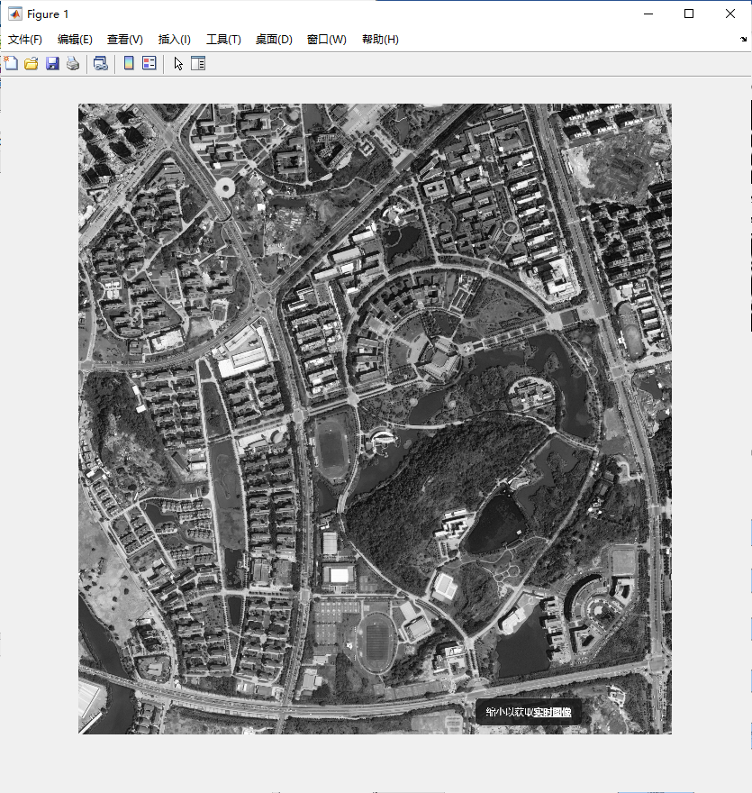
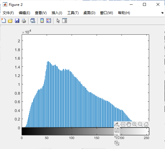
Figure 3. Convert the image to grayscale.
3A: Gray Graph, 3B: Grayscale Histogram.
2.2. Change the picture into a binary graph
We use MATLAB to separate road information from other information. Based on the data presented in Figure 4, roads are depicted using white images, while other relevant information is visually represented in black. This facilitates the execution of subsequent image processing tasks.
The following is the MATLAB code:
B = A > 140; | |
figure; | |
imshow(B); |
The observed outcome is as follows:

Figure 4. Binary Graph.
2.3. Convolution dilation and erosion
The application of the convolution expansion principle allows for the enlargement of the road dimensions within the satellite image, resulting in an enhanced and more distinct representation of the road. In order to enhance the processing of road images, the convolution erosion technique is employed to extract the white error associated with the road. This enables a more accurate differentiation between the road and surrounding structures, such as buildings. Ultimately, the processed white image is subtracted from the black image in order to obtain the base image. The depicted procedure is illustrated in Figure 5.
The following is the MATLAB code:
sa = ones(6, 6); | |
C = imdilate(B, sa); | |
figure; | |
imshow(C); | |
| |
E = bwmorph(C, 'skel', 6); | |
figure; | |
imshow(E); | |
| |
F = bwmorph(E, 'spur', 20); | |
figure; | |
imshow(F); | |
| |
sc = ones(4, 4); | |
G = imerode(F, sc); | |
figure; | |
imshow(G); | |
| |
H = imsubtract(F, G); | |
figure; | |
imshow(H); | |
| |
I = bwmorph(H, 'clean', 10); | |
figure; | |
imshow(I); |
The observed outcome is as follows:
|
|
A | B |
|
|
C | D |
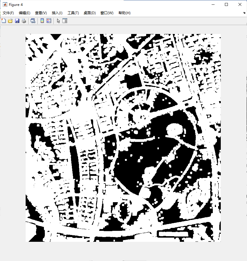
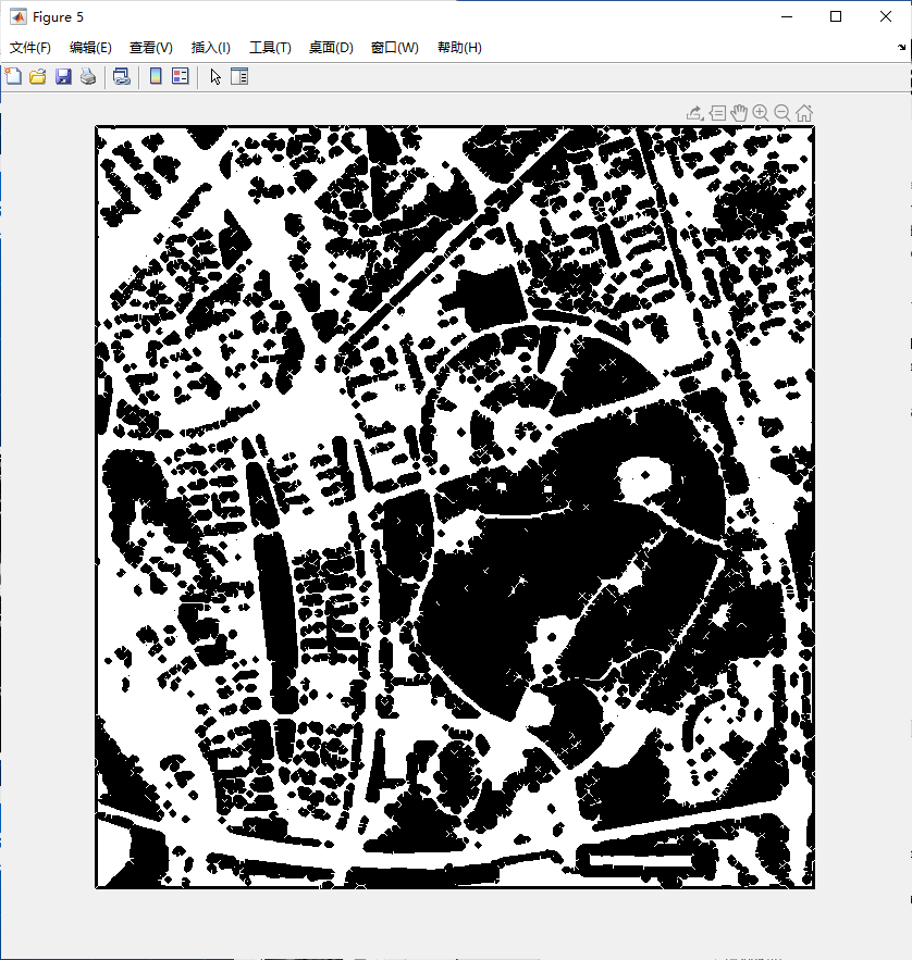
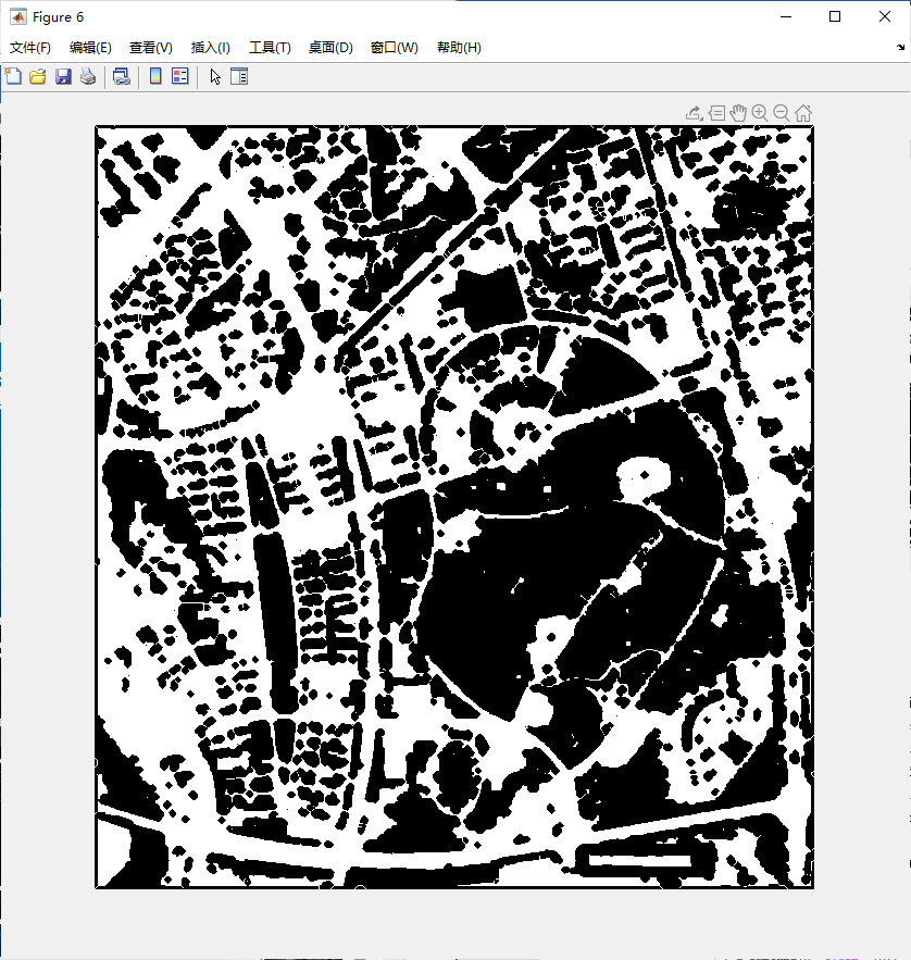
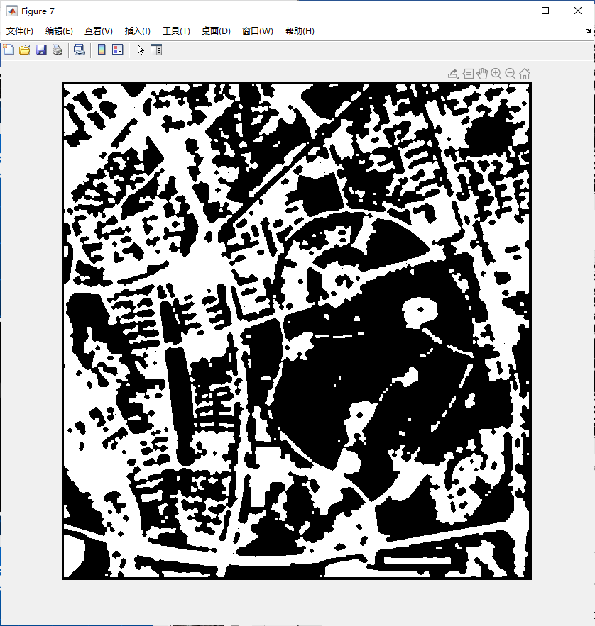
Figure 5. Perform convolution dilation and erosion operations on road images.
5A: Road image after Dilation, 5B: Road image after Skeleton Processing, 5C: Road image after Trimming (Burr processing), 5D: Road image after Erosion.
2.4. Processing of Image Details
The initial image captured by our team will inevitably exhibit some imperfections, such as distortions and artifacts, which are contingent upon factors such as image resolution and architectural conditions [3]. Based on the findings presented in Figure 6, it is possible to mitigate the presence of burrs in the image road image by employing the clipping function available in MATLAB. Ultimately, the image quality can be enhanced through the process of noise reduction.
The following is the MATLAB code:
H = imsubtract(F, G); | |
figure; | |
imshow(H); | |
| |
I = bwmorph(H, 'clean', 10); | |
figure; | |
imshow(I); | |
| |
J = imcomplement(I); | |
figure; | |
imshow(J); |
The observed outcome is as follows:
|
|
A | B |
| |
C | |
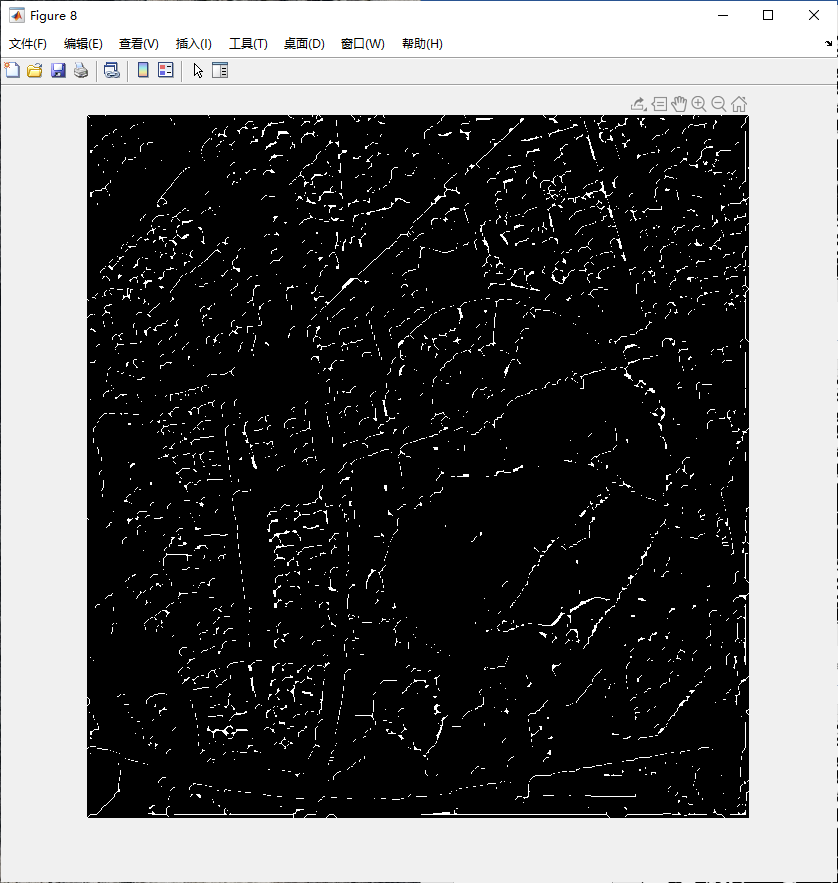
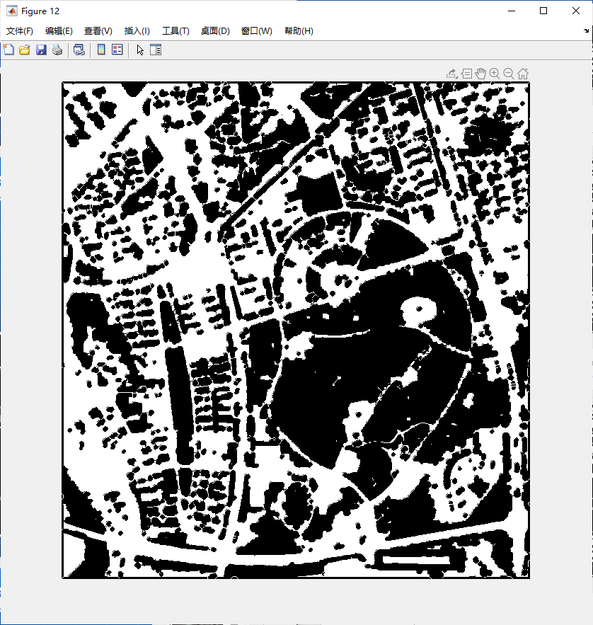
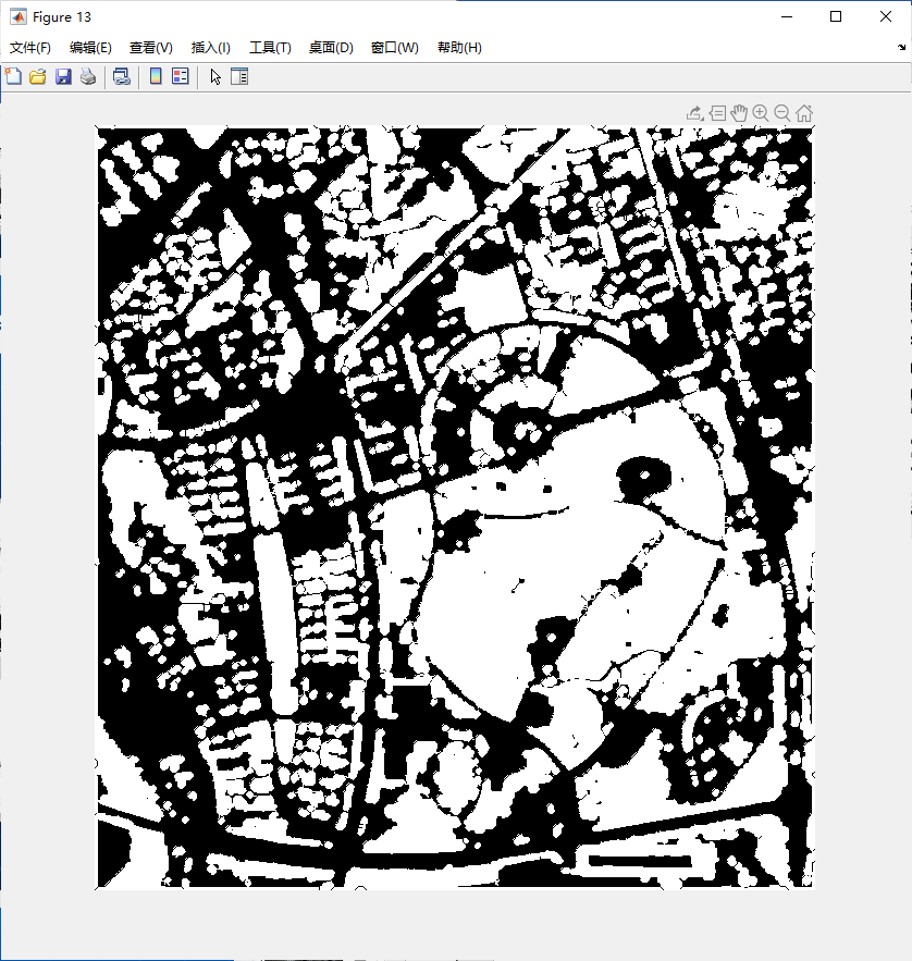
Figure 6. Perform detailed operations on road images.
6A: Image Subtraction, 6B: Noise Processing, 6C: Imcomplement Processing.
2.5. Comparison
Original Image |
|
Extracted Road |
|
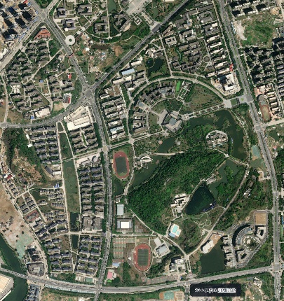
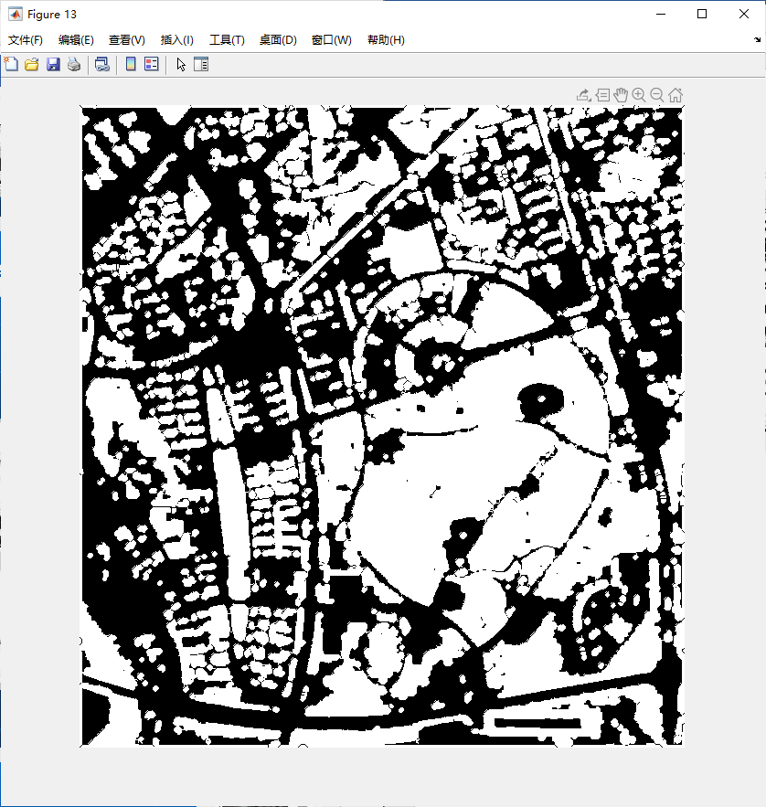
Figure 7. Comparison with the original image after the final operation.
7A: Original satellite road image, 7B: Road extracted after multiple operation.
3. Results & discussion
3.1. Results & Analysis
Up to this point, the fundamental objective of this project has been successfully accomplished, namely the extraction of road networks from satellite imagery. The impact of the project is illustrated in Figure 7.
Based on the comparative analysis conducted, it can be inferred that the program possesses the ability to accurately extract road information. However, it is evident that a disparity persists between our anticipated outcomes and the actual state of affairs. There are several potential reasons that can be considered:
To begin with, it is important to consider the inherent constraints associated with the image. Satellite imagery was obtained from the platform Zoom Earth. However, the image's resolution is insufficient, resulting in poor recognition of the road.
Additionally, there exist inaccuracies in the manual threshold selection process. According to the morphological approach, it is necessary to convert the satellite image into a grayscale representation in order to facilitate the extraction of road-related data.
The grayscale threshold necessitates manual adjustment. In conclusion, we select the image (Figure 3B) with a threshold value of 140, as it demonstrates the most prominent delineation of the road.
B = A > 140; | |
figure; | |
imshow(B); |
The manual determination of the threshold is characterized by a lack of precision. It is inevitable that errors will occur. Finally, it is imperative that we do not furnish the program with a means to ascertain the parameters of the roadway. Herein lies a more comprehensive examination of the aforementioned assertion. The criterion for the road infrastructure we offer to the program is based on a spectrum of grayscale intervals. Regrettably, our program is unable to provide a more detailed explanation of the purpose and function of a road. The core factor that we posit as the cause for the disparity between our expectations and the actuality is believed to be the aforementioned.
3.2. Additional Discussion
In addition, we engaged in a discourse with our colleagues who possess expertise in the field of Computer Science, wherein we deliberated upon the obstacles encountered throughout the course of the project. Subsequently, they adeptly resolved the aforementioned predicament by employing the k-means clustering methodology. The k-means clustering algorithm is a technique used for vector quantization. The process of clustering involves the partitioning of n observations into k clusters, wherein each observation is assigned to the cluster that has the closest mean, also known as the cluster center or cluster centroid [4,5].
Python was employed for the implementation of this project, where the utilization of k-means was pivotal for data processing. Each individual point was treated as a 3D vector, with its components corresponding to the RGB channels. The clustering process was primarily driven by the similarity of pixel colors, which are represented by these 3D vectors. Consequently, pixels sharing a high degree of similarity were assigned the same color, as shown in figure 8.
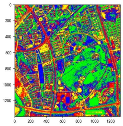
Figure 8. Using k-means clustering to group similar RGB pixels. ( The extracted road is represented by the red portion in the image.)
It is evident that the roads obtained through the utilization of k-means clustering exhibit a higher level of accuracy in comparison to those derived through morphological approaches. This finding offers a promising avenue for further investigation in the realm of study. In subsequent endeavors, we are inclined to explore the application of this technique in MATLAB for the purpose of extracting road networks from satellite imagery.
4. Conclusion
In this study, we applied morphological techniques to satellite imagery to extract road information, with MATLAB serving as the primary tool for project implementation. Through contrast enhancement, we improved the computer's capability to discern features within satellite images. Noise reduction was achieved using convolutional erosion and dilation methods. Additionally, our exploration of the k-means clustering method provided valuable insights, offering an enticing avenue for potential future research. Further investigation into this approach holds great potential for forthcoming endeavors.
The road segments derived from satellite imagery initially aligned with our predetermined criteria. Nevertheless, the level of precision provided by these devices is insufficient for applications that demand a high degree of accuracy, such as scientific surveying and mapping. Our forthcoming objective is to enhance the precision of road extraction. Our organization remains dedicated to persistently pursuing the goal of accurately extracting road networks from satellite imagery. Nevertheless, our study has some limitations. Firstly, while morphological methods were employed for road extraction, their effectiveness might be hindered in complex terrain and diverse road scenarios. Combining other image processing techniques, such as deep learning, could address this concern. Secondly, our method may be sensitive to noise and poor image quality, thereby affecting extraction accuracy. To address this limitation, advanced noise reduction and image enhancement techniques could be incorporated.
In future research, one notable direction is delving into deep learning approaches for satellite image processing, particularly convolutional neural networks (CNNs) [6]. These techniques hold significant potential for learning and extracting image features, possibly enhancing road extraction precision and robustness. Furthermore, exploring interdisciplinary collaboration, such as integrating road extraction with Geographic Information Systems (GIS), could facilitate practical applications in surveying and planning tasks [7].